- Distance 97km
- Altitude maximum n/c
- Altitude minimum n/c
- Marche 06h30
- Dénivelé positif 6030m
- Dénivelé négatif n/c
- Commune de départ Albiez-le-Jeune
- Nature du terrain Cailloux / Gravillons / Revêtement dur / Rocher / Terre
Description
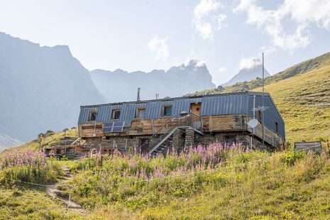
Touring the Aiguilles d'Arves is an adventure you won't soon forget! This alpine hike, for experienced hikers only, will plunge you into a sumptuous setting of mountain pastures, mineral peaks and welcoming refuges.
Septentrional, centrale and méridionale culminating at 3,514 meters above sea level, but also known as "Tête de Chat" or "Petit Jean", "Gros Jean" and "Jean Jean", these three emblematic mountains were conquered in 1893 by Valloire residents hunting chamois, and made famous by William Coolidge's ascents in 1873.
The Tour des Aiguilles d'Arves, a hiking itinerary between Savoie and Hautes-Alpes, takes you into a wilderness atmosphere, immersed far from everything, in a succession of high-altitude passes, panoramic ridges and flower-filled mountain pastures on whose slopes graze numerous herds of cattle, goats and sheep.
This interdepartmental itinerary, dedicated to the very best mountain hikers, combines history and trade, wars and peddlers, between the former State of Savoy and the Kingdom of France. Cross the border on these ancient paths steeped in history, on these slopes and crests!
It is advisable to book accommodation well in advance, as it has a small capacity.
It is advisable to book accommodation well in advance, given its small capacity.
Recommended equipment :
- Mountain boots suitable for walking on varied terrain (rigid soles)
- Rain gear
- Warm clothing
- Pair of telescopic poles
- Cash (CB terminals not always available in refuges)
1/ DAY 1: Albiez-le-Jeune -> Chalet d'la Croë / Duration: 6h15 / Difference in altitude: + 878 m / -174 m / Distance: 14.8 km
2/ DAY 2: Chalet d'la Croë -> Chalet du Perron / Duration: 4h / Difference in altitude: + 536 m / - 463 m / Distance: 8.3 km
3/ DAY 3: Chalet du Perron -> Refuge du Pic du mas de la Grave / Time: 7h30 / Difference in altitude: + 1087 m / - 1290 m / Distance: 12.7 km
4/ DAY 4: Refuge du Pic du mas de la Grave -> Refuge du Goléon / Duration: 7h / Difference in altitude: + 1048 m / - 525 m / Distance: 15.2 km
5/ DAY 5: Refuge du Goléon -> Refuge des Aiguilles d'Arves / Duration: 7h50 / Difference in altitude: + 993 m / - 1217m / Distance: 15.5 km
6/ DAY 6: Refuge des Aiguilles d'Arves -> Albanne / Time: 7h45 / Difference in altitude: + 649 m/ -1279 m / Distance: 17.4 km
7/ DAY 7: Albanne -> Albiez-Le-Jeune / Duration: 6h40 / Difference in altitude: + 825 / - 1078/ Distance 13.2 km
Aiguilles d'Arves Tour
-
Zone de loisirs des Léchères, 124 Route de Villargondran
Chef-lieu
73300 Albiez-le-Jeune - 04 79 59 30 48
-
Opening
From 20/06 to 20/09.
Subject to favorable weather. - Contact Télécharger le fichier GPX
-
Prices
- Free access.